
Heads up: some of the links in this post are affiliate links. That means if you click and purchase, we may get a commission. It’s how we keep this site running without cluttering it with ads.
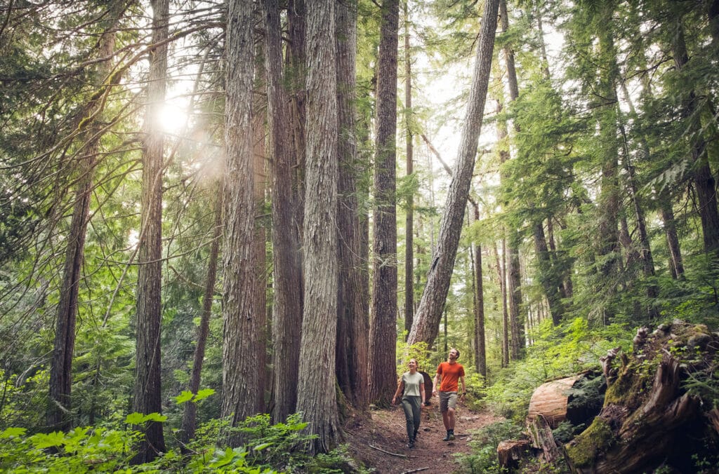
Whistler offers some of Canada’s most stunning hiking experiences, with trails that wind through ancient forests, lead to cascading waterfalls, and provide access to glacier-covered peaks. Whether you’re looking for a gentle walk through interpretive forests or a challenging trek to alpine viewpoints, this mountain destination has options for every skill level. Just make sure you’re properly equipped before heading out—many Whistler trails involve slick roots, rocky climbs, and unpredictable mountain weather, which is why having proper footwear like the options featured in our guide to the best hiking boots in Canada can make a big difference in comfort and safety on the trail.
You'll find everything from easy lakeside strolls to demanding glacier approaches, plus essential information about trailheads, parking, and seasonal considerations to help you plan your adventure. The region's diverse terrain includes provincial parks, protected forests, and high-altitude routes that showcase British Columbia's natural beauty throughout the hiking season.
9. Ancient Cedars Trail
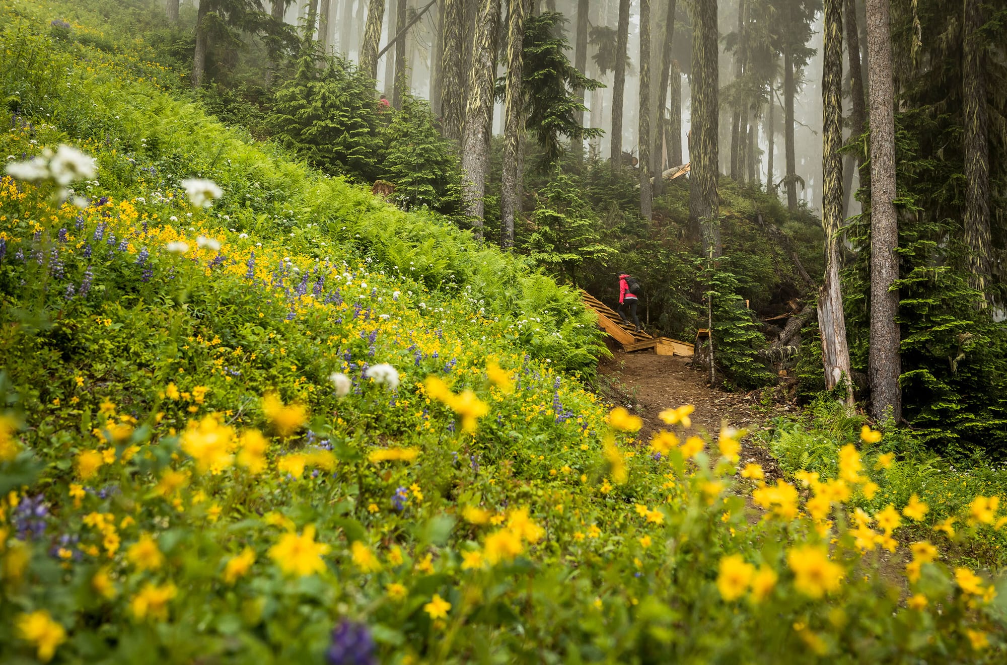
The Ancient Cedars Trail takes you through some of Whistler's most impressive old-growth forest. You'll walk among massive cedar trees that are hundreds of years old. These giant trees create a peaceful atmosphere that feels almost magical.
The trail is fairly easy and works well for most fitness levels. You can complete the main loop in about an hour. The path is well-maintained with boardwalks in some sections.
This hiking area gives you a chance to see what BC's forests looked like long ago. The cedars tower high above you as you walk the quiet trail. Many visitors say this hike feels different from other Whistler trails.
You'll find the trailhead has good parking space for your visit. The trail connects to other hiking routes if you want a longer adventure.
Rating: 4.4 (52 reviews)
Location: Whistler, BC V0N 1B9, Canada
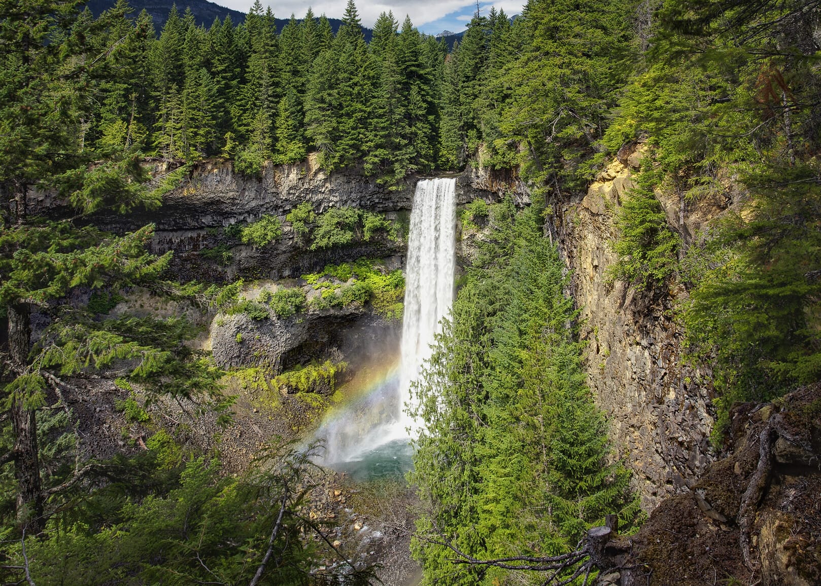
8. Rainbow Falls
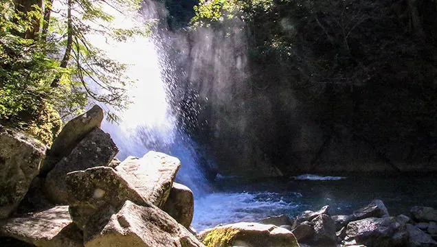
Rainbow Falls offers one of Whistler's most rewarding waterfall hikes. The trail takes you through dense forest to reach this impressive cascade that drops over rocky cliffs.
You'll follow the Rainbow Lake Trail to reach the falls. The hike is moderate and takes most people about 2-3 hours round trip. The path winds through old-growth trees and crosses several small streams.
The waterfall creates a misty spray that often forms rainbows on sunny days. You can get close to the base of the falls for photos and to feel the cool mist. The area around the falls has large boulders where you can rest and enjoy the view.
The trail is well-marked but can be muddy in spring and after rain. You should wear good hiking boots with grip. The best time to visit is late spring through early fall when the water flow is strong.
Rating: 4.7 (147 reviews)
Location: Rainbow Lake Trail, Whistler, BC V8E 0C3, Canada
7. Blackcomb Glacier Provincial Park
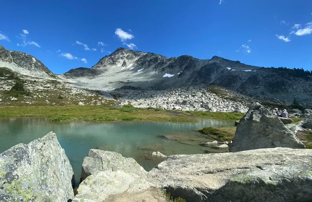
Blackcomb Glacier Provincial Park covers 250 hectares of mountainside terrain near Whistler. You can access hiking and skiing trails that wind through diverse wildlife habitat.
The park sits at high elevation, giving you views of glacial features and alpine landscapes. Wildlife viewing opportunities exist throughout the area as you explore the trail system.
You'll find this provincial park offers year-round outdoor activities. The trails provide access to both summer hiking and winter skiing depending on the season.
The park connects you with the natural alpine environment of the Coast Mountains. You can experience the glacial geography that shaped this region over thousands of years.
Rating: 4.9 (331 reviews)
Location: 4899 Painted Cliff Road, Whistler, BC V0N 0A0, Canada
Website: Visit Website
6. Ascent Trail
The Ascent Trail offers a challenging uphill hike that connects Whistler's Upper Village to Rendezvous Lodge on Blackcomb Mountain. This 6.2-kilometer trail gains 1,200 meters of elevation through three sections called Little Burn, Big Burn, and Heart Burn.
You'll hike through beautiful coastal rainforest filled with ancient trees up to 250 years old. The trail features well-built bridges, staircases, and chains along rocks to help with the steep sections. Western hemlock, yellow cedar, and Douglas fir trees create a lush canopy above the moss-covered forest floor.
The trail takes about two hours to reach the gondola midstation. From there, you can buy a $15 download ticket to ride back down instead of walking. This saves your knees from the tough downhill journey.
If you continue to the top, you can access restaurants and connect to other mountain lifts. The trail works well for hikers with good fitness who want a serious workout in a stunning forest setting.
Rating: 4.9 (8 reviews)
Location: 4553 Blackcomb Wy, Whistler, BC V8E 0Y1, Canada
Website: Visit Website
5. Lost Lake Park
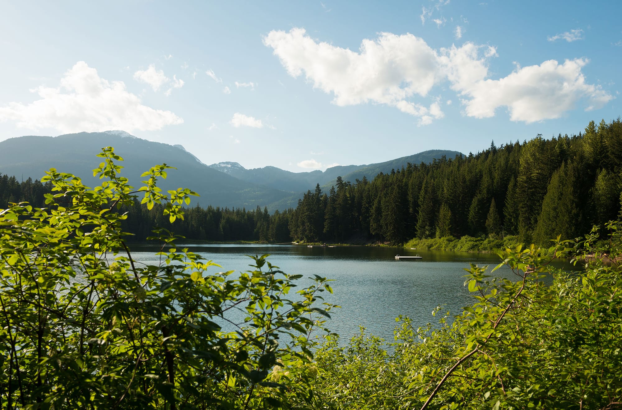
Lost Lake Park offers a perfect mix of easy hiking trails and beautiful lake views in Whistler. The park features a circuit trail around the lake perimeter that works great for both walking and biking.
You can explore over 25 km of trails during summer months. The main loop trail takes you around the quiet lake through forest areas. The trails are multi-use, so you'll share them with bikers on most paths.
The park has a sandy beach area where you can take breaks during your hike. You'll find picnic tables, washrooms, and even food trucks during peak season. The park stays open from dawn to dusk between April and mid-December.
Getting there is easy with free shuttle service from Whistler Village during summer. The shuttle runs every 10-20 minutes from June to September. You can also bike there on the paved Valley Trail or drive to nearby parking lots.
Rating: 4.7 (1,463 reviews)
Location: 4700 Lost Lake Rd, Whistler, BC V8E 0Z5, Canada
Contact: +1 604-932-5535
Website: Visit Website
Support The Canada Report and help keep it ad-free and independent — click here before you shop online . We may receive a small commission if you make a purchase. Your support means a lot — thank you.
4. Skywalk Trailhead
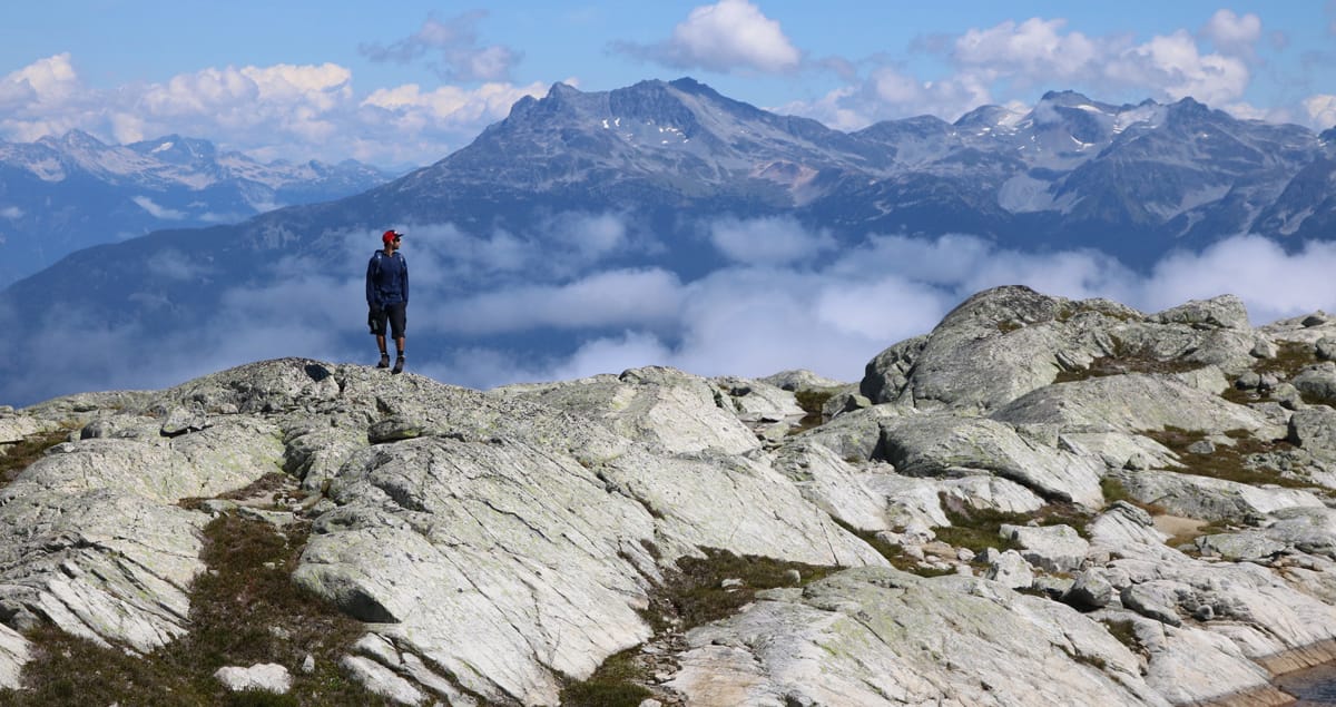
The Skywalk North Loop takes you into Whistler's alpine wilderness for amazing views of Rainbow Glacier and Iceberg Lake. This challenging trail starts on Mountain View Drive and climbs high into the backcountry.
You'll hike through forests and meadows before reaching the main highlights. The route passes Screaming Cat Lake and continues to Iceberg Lake at the base of Rainbow Mountain. Snow can stay at higher elevations until July.
The trail network can be confusing to navigate, especially in lower sections. The full loop uses several connected trails including the Lower 19 Mile Creek Trail and Screaming Cat Lake Connector. You'll gain lots of elevation early, so pace yourself carefully.
This demanding hike rewards you with views of multiple mountain ranges and glacial lakes. The route requires good fitness and navigation skills. Most hikers need a full day to complete the north loop section.
Rating: 4.7 (74 reviews)
Location: Mountain View Dr, Whistler, BC V0N 1B8, Canada
Contact: +1 604-754-8993
Website: Visit Website
3. High Note Trail

The High Note Trail offers some of the best mountain views in Whistler. You start at the top of Whistler Mountain after taking the gondola and Peak Chairlift up.
This trail takes you around the backside of Whistler Mountain with amazing views of Cheakamus Lake. The turquoise lake sits below as you walk along the mountainside. In early August, you can see colorful wildflowers in bloom.
You'll hike through alpine areas and rocky sections before reaching Symphony Lake in Sun Bowl. The trail has one tricky spot where you need to use a rope and metal walkway. Most hikers can handle this easily.
The route ends at Harmony Lake before climbing back to the gondola. You'll walk downhill for most of the hike, then face a final uphill section at the end. The whole loop takes several hours to complete.
Rating: 4.8 (38 reviews)
Location: Whistler, BC V0N 1B4, Canada
Website: Visit Website
2. Whistler Interpretive Forest
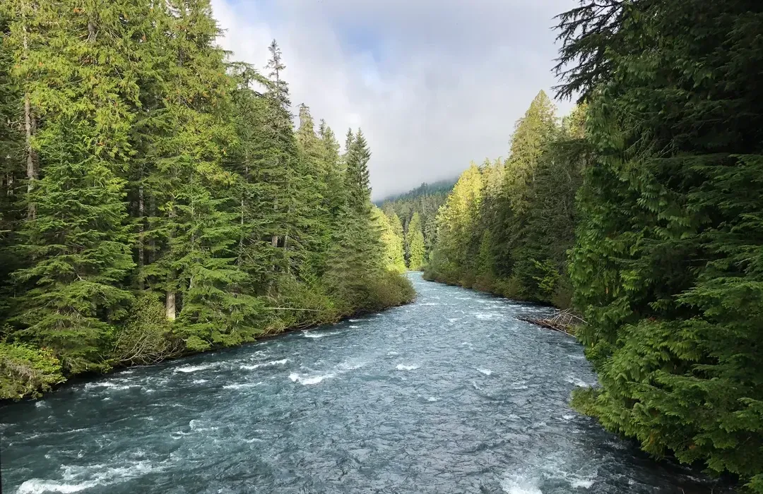
The Whistler Interpretive Forest offers you a unique blend of education and outdoor recreation on 3,000 hectares near Cheakamus Crossing. You'll find this area just off Highway 99, where active logging operations work alongside hiking trails and interpretive displays.
The trail network includes several popular options for your hiking adventure. You can explore the Riverside Trail, which features the MacLaurin Crossing suspension bridge over the Cheakamus River. The Loggers Lake Trail takes you up a rock bluff to a hidden lake with a wooden pier.
As you hike, you'll encounter interpretive signs that explain the local plants, animals, geology, and logging history. The forest shows different stages of growth, from old-growth stands to newer plantations of various ages. This gives you a chance to see how forests change over time.
The area is managed jointly by the Lil'wat and Squamish First Nations, the Resort Municipality of Whistler, and the Ministry of Forests. They balance logging activities with recreation and wildlife protection using sustainable practices.
Rating: 4.6 (178 reviews)
Location: 1011 BC-99, Whistler, BC V0N 0A0, Canada
Contact: +1 604-935-8398
Website: Visit Website
1. Brandywine Falls Provincial Park
Brandywine Falls Provincial Park offers one of the most popular hiking experiences near Whistler. The park features a 70-meter waterfall that drops over volcanic rock walls.
The main Brandywine Falls Trail takes you on a 10 to 20 minute walk through forest to reach the waterfall viewing platform. You'll cross a covered footbridge before arriving at the first viewpoint. A second short path leads to another viewpoint where you can see Daisy Lake and the Black Tusk mountain.
The park also has the Swim Lake Trail, which branches off the main trail before the railway crossing. This rougher path includes one steep climb and leads to a small lake. You might spot the rare red-tailed frog that lives in the park's marshes and ponds.
For longer hikes, you can access the Sea to Sky Trail and Lava Lake Trail from the park. These trails are shared with cyclists, so stay alert while hiking. The park includes picnic areas for rest stops during your visit.
Rating: 4.7 (3,307 reviews)
Location: BC-99, Whistler, BC V0N 1B1, Canada
Contact: (800) 689-9025
Website: Visit Website
Tips for Hiking in Whistler
Success on Whistler's trails depends on proper gear, following safety protocols, and timing your hikes with the mountain weather patterns. The right preparation helps you enjoy everything from easy forest walks to challenging alpine routes.
Essential Gear Recommendations
Your footwear makes the biggest difference on Whistler's varied terrain. Waterproof hiking boots with good ankle support work best for rocky trails and creek crossings.
Pack these items for day hikes:
- Navigation: Map, compass, or GPS device
- Sun protection: Sunglasses, hat, and SPF 30+ sunscreen
- Insulation: Extra layers including a rain jacket
- Illumination: Headlamp with extra batteries
- First-aid supplies: Basic medical kit
- Fire starter: Waterproof matches or lighter
- Repair kit: Duct tape and multi-tool
- Nutrition: Extra food beyond your planned meals
- Hydration: Water bottles or hydration system
- Emergency shelter: Space blanket or bivy
Dress in moisture-wicking layers rather than cotton. The weather changes quickly in the mountains. Bring more water than you think you need, especially on longer trails.
Trail Etiquette and Safety
Stay on marked trails to protect fragile alpine plants and prevent erosion. Cutting switchbacks damages the mountainside and creates dangerous shortcuts.
Yield to uphill hikers since they work harder and have less visibility. Step aside on the downhill side of the trail. When meeting mountain bikers, they should yield to you.
Tell someone your hiking plan before you leave. Include your route, expected return time, and backup plans. Check weather conditions and trail reports from local sources before heading out.
Wildlife encounters happen frequently in Whistler. Make noise while hiking to avoid surprising bears or cougars. Store food in bear-proof containers or hang it properly. Never feed wildlife.
Carry bear spray and know how to use it. Keep it easily accessible, not buried in your backpack.
Seasonal Considerations
Summer hiking season runs from July through September when most high-elevation trails become snow-free. Lower elevation trails like those around Lost Lake stay accessible from May through October.
Spring conditions change rapidly between 3,000 and 6,000 feet elevation. Snow patches remain on north-facing slopes well into July. Creeks run high from snowmelt, making crossings dangerous.
Winter hiking requires snowshoes or microspikes for most trails. Daylight hours shrink to less than 8 hours in December and January. Avalanche risk increases significantly on steep terrain above treeline.
Fall brings stunning colors but also wet conditions. Rain starts increasing in September. Trails become muddy and slippery. Temperatures drop quickly after sunset, so start early and finish before dark.
Check current trail conditions and difficulty levels before choosing your route during shoulder seasons.
Accessing Whistler's Trails
Getting to Whistler's trails requires planning your transportation and parking, understanding which trails welcome dogs, and knowing how to read trail maps effectively. Most trailheads are accessible by car with designated parking areas, though some require shuttle access or gondola rides.
Transportation and Parking
You can reach most Whistler trailheads by car along Highway 99 or local roads within the resort area. Popular trails like Cheakamus Lake and Train Wreck have dedicated parking lots that fill up quickly during peak season.
Arrive early in the morning, especially on weekends, to secure parking spots. Many lots reach capacity by 9 AM during summer months.
Free parking is available at most trailheads including:
- Cheakamus Lake trailhead
- Train Wreck trail parking area
- Brandywine Falls lot
- Joffre Lakes parking (though this requires advanced reservations)
Some trails require paid parking or alternative transportation. The Peak Express Gondola provides access to High Note Trail and other alpine routes for a fee.
Public transit options are limited for trail access. Most hikers rely on personal vehicles or rental cars to reach trailheads outside the village core.
Dog-Friendly Trails
Many Whistler trails welcome leashed dogs, but restrictions vary by location and season. Provincial parks often have different rules than municipal trails.
Dog-allowed trails include:
- Train Wreck Trail
- Cheakamus Lake Trail
- Valley Trail system
- Most village-area walking paths
Dog restrictions apply to:
- Joffre Lakes Provincial Park (dogs prohibited)
- Some alpine areas during wildlife seasons
- Certain sections of Garibaldi Provincial Park
Always keep dogs leashed and pack waste bags. Wildlife encounters are common, so maintain control of your pet at all times.
Check current regulations before heading out, as rules change seasonally to protect wildlife like bears and mountain goats.
Navigating Trail Maps
AllTrails provides 175 scenic trail options in Whistler with detailed maps and user reviews. Download offline maps before hiking since cell service can be spotty on mountain trails.
Essential map features to look for:
- Elevation gain and distance
- Trail difficulty ratings
- Current conditions and closures
- Water sources and viewpoints
Paper maps are available at the Whistler Visitor Centre and many hotels. These backup maps prove valuable when phone batteries die or GPS signals fail.
Trail markers in Whistler use standardized symbols and colors. Blue markers indicate easier routes, while black diamond signs mark advanced trails requiring experience.
GPS coordinates help locate exact trailheads, especially for lesser-known routes. Save these coordinates in your phone before leaving cell service areas.
Frequently Asked Questions
Hikers often have specific questions about trail difficulty, family options, and timing for Whistler adventures. These answers cover the most challenging routes, scenic viewpoints, seasonal considerations, and hidden trails that experienced hikers seek.
What are the top-rated hiking trails in Whistler for experienced hikers?
Experienced hikers should tackle the challenging routes that offer adventure for all levels. Blackcomb Glacier Provincial Park provides demanding terrain with glacier access and alpine conditions.
The Ascent Trail delivers steep elevation gain and technical sections. You'll face rocky terrain and extended climbs that test your endurance.
Advanced hikers also enjoy multi-day backpacking trips in the backcountry. These routes require navigation skills and wilderness experience.
Which family-friendly hiking trails are recommended in Whistler?
Lost Lake Park offers the perfect starting point for families with young children. The loop trail stays flat and provides easy walking on well-maintained paths.
Ancient Cedars Trail gives families a chance to see old-growth forest without steep climbs. The trail remains relatively flat through the entire route.
Rainbow Falls provides a moderate family option with a rewarding waterfall destination. Kids enjoy the water features and shorter distance to the viewpoint.
What are the best hiking trails in Whistler with scenic views?
Rainbow Falls delivers stunning water views and forest scenery along the entire route. You'll enjoy multiple viewpoints of the cascading water.
Blackcomb Glacier Provincial Park offers alpine views with mountain peaks and glacier sights. The high elevation provides panoramic mountain vistas.
Trail routes around serene lakes give you reflective water views surrounded by peaks. These locations offer perfect photo opportunities with mountain backdrops.
Can you suggest the most challenging hiking trails in the Whistler area?
The Ascent Trail ranks among the most demanding routes with steep elevation gain and technical terrain. You'll climb over rocky sections and face sustained uphill grades.
Blackcomb Glacier Provincial Park challenges experienced hikers with alpine conditions and glacier access. The route requires proper mountaineering gear and weather awareness.
Multi-day backpacking trips push your limits with extended wilderness camping. These routes demand navigation skills and self-sufficiency.
What are the best times of year to hike the trails in Whistler?
Summer months from July through September provide the best trail conditions and weather. Snow clears from higher elevations and temperatures stay comfortable for hiking.
Spring hiking in May and June works well for lower elevation trails. You'll find fewer crowds but some high alpine routes may still have snow.
Fall offers excellent hiking through October with cooler temperatures and changing leaves. Weather becomes less predictable as winter approaches.
Are there any lesser-known hidden gem trails in Whistler for avid hikers?
Ancient Cedars Trail remains less crowded than popular routes while offering impressive old-growth forest. Many hikers overlook this trail for more famous destinations.
Remote sections of Blackcomb Glacier Provincial Park provide solitude for experienced hikers. You'll find unmarked routes that require navigation skills and wilderness experience.
Local hiking guides know lesser-traveled paths that avoid tourist crowds. These routes offer authentic wilderness experiences away from busy trailheads.